Showing posts with label Huntingdon. Show all posts

Wednesday, May 10, 2017

Minersville Coke Ovens


In the southern part of Huntington county between the small towns of Coalmont and Dudley, there is a set of coke ovens and remnants of a mining operation. Minersville was founded in 1875 and quickly burnt out like so many others of it's era. Only part of this historic area is accessible via State Game Lands, the other part is noticeably posted as private land.

We parked our car and set out to explore the area. The Michell and Beehive ovens were easily seen even with mother nature reclaiming them. Some of the ovens were fallen in, but most were still in decent shape. At one time over 150 ovens were in operation. Upon closer observation we found a few foundations to buildings. From the road we could see the remains of a tipple and concrete structures; however, the land they are on is posted.

Heading east from Coalmont along Route 913 about one mile the road leading to the State Game Lands and Minersville is not marked and is simply a right turn onto a dirt road that leads to a bridge over Shoup Run. Please be mindful of the private property.


Tuesday, August 16, 2016

Trough Creek State Park


Balance Rock
Trough Creek State Park is one of Pennsylvania’s smaller state parks but that doesn’t stop it from having some of the best views and natural attractions. This rustic state park is situated in the middle of Huntingdon County and just a short distance east from Raystown Lake. The over 500 acre park offers camping, fishing, hiking, picnic areas and even and old stone mansion you can rent.

Through Creek was founded like so many other state parks in Pennsylvania. Early pioneers trying to get ahead in the late 1700’s built small iron furnaces and cleared land to conquer the new frontier. In the 1930’s Civilian Conservation Corps (CCC camps) were made to employ young men and revitalize the land that was stripped from its resources. Later many of the CCC camps were made into the state parks we have today.

Paradise Furnace
     The area of trough creek attracted the attention of the iron master Rueben Trexler in the early 1800’s. The area was rich with iron, trees, and water to power mills; everything needed for a profitable iron smelting business. Trexler built his first furnace in 1818 and later built the Trough Creek Furnace that increased production. In 1832, John Savage leased the furnace and renamed it the Mary Ann Furnace and built a forge. The furnace production died down for a few years until the American Civil War. At that time iron was in high demand again and the furnace flourished again.. The son of Rueben Trexler, Horatio, took over his father’s furnace and renamed it Paradise Furnace after the war. By the early 1900’s the Iron production had taken its toll on the surrounding land. The forest had been depleted to make charcoal and floods and forest fires were prevalent and the area was vacant.

Side view Paradise Furnace
     In the 1930’s many young American men were unemployed due to the Great Depression. One attempt to correct this problem was the building of Civilian Conservation Corps(CCC). This allowed young men to learn new skills, earn some money, and fix the ecosystems that were destroyed by tree and mineral stripping. The CCC camp S-57 of Trough Creek was also known as Camp Paradise Furnace and built Trough Creek State Park. The state park officially opened in 1936.

So what makes Trough Creek unique compared to other State Parks? Well this park has plenty to offer in its rich history in the iron industry; as well as, many natural landmarks. Paradise Furnace still exists and can be visited today.

Paradise Cemetery
     The Furnace still stands about 20 feet tall but part of its wall has fallen in. Across from the furnace the original Iron Master’s home sits atop a hill overlooking Paradise Furnace. The Iron Master's mansion, Trough Creek Lodge, was renovated and available for year round renting. A short walk along Cemetery Trail will lead you to Paradise Cemetery. Along this trail remains of the mill can be found if you look hard enough. Paradise Cemetery is an old pioneers cemetery with mainly fieldstones marking the graves of the interments. Rumor has it that an Indian was buried in one of the corners of the cemetery. Tales tell of the Indian's ghost haunting the cemetery at night.

Looking down into the mine
     Another part of man’s mark on trough creek can be visited at the Ice Mine. The mine was believed to be dug by early pioneers prospecting for iron ore. No iron was found but unintentionally a fascinating geologic area was made. The Ice Mine is believed to work when cold winter air seeps into the mountain above the mine in the winter. During that time the air is collected and through the summer the cold air escapes down the mountain and into the mine. This allows freezing temperatures in the mine during the summer and through condensation ice to form on the roof of the mine even through the hottest summer days. This is a great spot to stop after a long hike to cool off.

Rainbow Falls
     A short distance from the Ice Mine, one of the most visited places in Trough Creek is Balance Rock and Rainbow Falls. Along Trough Creek Drive, before the Ice Mine, there is a small pull off to the right to park. Directly across from the parking area if you look upwards 
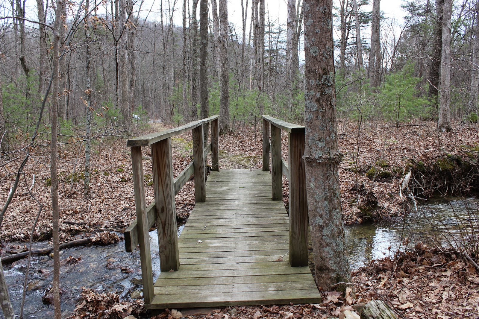
you will see Balance Rock hanging over the Great Tough Creek. Following Balanced Rock trail down into the gorge, you first have to cross the creek over a suspension bridge. Continuing up the trail Rainbow Falls is seen to the left of the trail. The best time to see this waterfall is in the spring or fall when the water level is at its max. During the summer months the stream feeding into Rainbow Falls tends to dry up. After passing Rainbow Falls a short hike up the hillside leads you to Balance Rock. After thousands of years of erosion, Balance Rock was cut from the different rock around it and appears to dangle over the gorge below.

Balance Rock
     Another geographical wonder is Copperas Rock. This out outcrop of rock was also made by years of erosion and many different rock layers can be seen. Trough Creek Drive will take you past Copperas Rock on your way to Balance Rock and the Ice mine. Some Folklore pertains to Copperas Rock. Some believe Edgar Allen Poe visited this area and after seeing the many ravens that live in the rock formation he was inspired to write one of his most known works. No real factual evidence lends creditably to this claim but it is still fun to think about.

Trough Creek Sate Park is a great place to plan a day visit or camp for a long weekend. The many sights, hiking trails, and fishing is enough to make any outdoors person happy. The easiest way to reach Trough Creek is by taking route 994, Old Plank Road, and watching for the signs direct you to Trough Creek. 
Inside the Ice Mine
Along Balance Rock trail


The Suspension Bridge


Monday, October 5, 2015

Unique PA Festivals - Harts Log Day

   
     In the small town of Alexandria, Pennsylvania, a festival takes place annually on the 2nd Saturday in October. The festival in many ways is similar to other autumn festivals in Pennsylvania. However, the history behind the town and the festival's name is unique.

      In the 1740's, an Indian trader named John Hart set up his trading post near present day Alexandria. Hart would use a hollowed-out log at his post to feed his horses while making trades. Through the years, the log he used became a landmark for early pioneers and was later referred to as Hartslog Settlement. In 1755, Hartslog Settlement and 400+ acres were bought by James Sterrat and in 1793, the town of present day Alexandria was laid out into blocks.

      Today the people of Alexandria continue to celebrate their heritage and autumn with the Hartslog Day Festival. Many hand-made crafts and venders line the main street through the town. Parking is free and available at both east and west entrances if you arrival early enough to get a spot. Local churches, organizations, fire companies, and other venders have great food throughout the festival. One local church even offers breakfast if you get their early in the morning. The festival is usually over sometime around 5-o-clock in the afternoon and is only a one days event. Alexandria is located just a short distance west of Huntingdon, Pennsylvania.


Wednesday, September 9, 2015

Lost Resting Places: Sheridan Cemetery


Sheridan School & Cemetery
View from Morgans Road
     In Huntingdon County, on the eastern side of Raystown Lake, there is a small cemetery that is overgrown with weeds and disheveled. Alongside the cemetery is a brick building that is also in need of some repairs. With a lot of research I could not find out much about this building or cemetery. The graveyard is known as Sheridan Cemetery but the building is called a school. I found it odd that a school would be next to a cemetery and believe it must have been a church at sometime and made into a school or vise versa.
 
            The cemetery has about twenty head stones dating from the mid 1800’s to the early 1900’s. Most of the stones are overgrown with plants and flowers that had been left there long ago. The cemetery and building sit alongside Morgans Road north of the intersection of Chilcote’s and Morgan’s Road. Please be respectful of the site if you wish to visit.

Wednesday, April 15, 2015

MayFest : Huntingdon's Spring Festival


   Pennsylvania sure has its share of unique festivals each year. While most of these festivals take place in autumn during the harvest season, one very unique festival in Huntingdon county helps to usher in the beginning of spring. In the borough of Huntingdon, this year will mark the 10th Annual MayFest. This uncommon festival usually takes place in the last weekend of April from 9am to 5pm. For the festival celebration, 5 blocks of  downtown Huntingdon are blocked off for venders, crafters, and some very special entertainment. What makes MayFest truly unique is how each block of downtown captures a different time era including Renaissance, 50's, Woodstock, Colonial, and Victorian. Activities, music, and entertainment center around each blocks time period.  Meanwhile, volunteers and re-enactors dress accordingly to the period. Most of the small business, cafes, and shops in downtown Huntingdon are also open. Some of the shops even offer specials during the festival. All the funds raised during MayFest go to help community non-profit groups.       

     I first heard about the festival a few years ago from a friend that lives in Huntingdon. For the past 2 years I have attended MayFest and plan on going this year on April 25th.  For anyone who loves small town festivals, this one is a must to attend and I strongly encourage it. For a festival goer like me, it is nice to have this festival “bridge the gap” between the autumn festivals. The easiest way to reach Huntingdon is by Route 22. Parking is available in a few different parts around town.

Monday, March 2, 2015

The Abandon Sideling Hill Railroad Tunnel


Southern Portal
     One thing Central Pennsylvania has is an abundance of railroads. That being said there is a lot of history to be explored along those old iron rails. I had recently started to research an abandon stretch of track known as the East Broad Top (EBT) Railroad that is near where I live. I had grown up hearing about the track but never really investigated it until recently. One subject that appealed to me was an abandon railroad tunnel along the EBT named Sideling Hill Tunnel. I recognized the name immediately and thought it had to do with the abandon stretch of Pennsylvania Turnpike, but was mistaken.

     The Sideling Hill Railroad Tunnel got its name from passing through Sideling Hill, which is more like a mountain, and stretches a good part of Pennsylvania. In 1873, it was decided that going through Sideling Hill would be the easiest route for the EBT railroad and boring began at both ends. About 1 year later, the little over 800-foot tunnel was completed. The tunnel had a “horseshoe” curve to it, and would later become a design flaw. In 1911 a locomotive wrecked due to wind freezing water on the tracks. Shortly after the accident, large wooden doors were made to close the tunnel and prevent
freezing. In 1919 a concrete portal was made at the north portal with new metal roll up doors. Men would operate the doors all year around. Then in 1948 the doors became automated to save money. Today you can find the rusted remains of the roll up metal door at the northern portal.

     Currently the tunnel still remains but is slowly fading away. Water is pooled in the tunnel floor, and rocks have fallen throughout the tunnel making it very hazardous. The southern portal is almost caved in completely. We parked in the SGL and walked a good distance with GPS coordinates in hand. Finally, we came upon an old stretch of the EBT railroad. Trees and bushes had reclaimed most of the old rails. We came across the southern portal and didn’t want to chance walking through the tunnel. Our visit was cut short due to the evening creeping up on us and we didn’t get to visit the northern portal. Hopefully we will get a chance to visit it soon.

      The easiest way to reach the tunnel is by Route 944 (old plank Road) between Broad Top City and Three Springs. When driving, look for overgrown railroad tracks and follow them a few hundred years. A parking lot for SGL 121 is a short distance from the tracks. I do not advise anyone to go inside the tunnel due to the very dangerous condition it is in.

Thursday, October 9, 2014

A Ghostly Chase at Coles Station

Coles Water Tank Shelter
      Recently I heard a lead about a ghost that used to terrorize locals near the Coles Station of the East Broad Top Railroad (EBT). Living only about an hour away from parts of the EBT, I never really looked into the history of the rail line or its importance. I was pleased to find out some new history and places to explore, but that is for another blog. 

      With a little research online and at the library, I was able to find an account of a haunting near Coles Station. On a late evening in May of 1906 two men, Luther Chilcote and William Elias, were walking back from a social evening with friends. They choose to walk the easiest route over Coles Summit to their homes. At the summit, near Coles Station of the EBT, they saw in the distance a woman in a white dress. The men began to try to get her attention but she didn't respond to them. The men began to realize she was an apparition as she came closer. The men fired their hand guns in fright as the women drew nearer. After the volley of shots, the apparition started to chase them into the valley. The men reached their home and quickly shut the door behind them. In the days that followed, the men actually reported the incident to the local papers. Thankfully they did to preserve this piece of history.

      Coles Station has sadly razed for many years now and can be found as a rectangular foundation being reclaimed by nature. However, the Coles Water Tank shelter has survived due to recent volunteer work and its difficulty to get access to. The Station was just a little west of the water tank shelter. The water tank structure housed a large wood tub that provided water to the steam locomotives of the EBT. Water was pumped by an engine out of a cistern from a nearby spring. The structure you can visit now was built sometime around 1919 and replaced an earlier building. Thankfully this piece of history has been restored and gives a good sign to where the ghostly women in white was seen. Coles Summit lies east of Three Springs in Huntingdon County near Route 994/Old plank road.

Friday, August 29, 2014

Brumbaugh Homestead


      While a few friends and myself were on our way to go fishing in Raystown Lake, we decided to make a detour trip to an old home I had heard about. Heading north of Marklesburg on Route 26 we made a right hand turn on Weller Road. Traveling back the dirt road we approached a small turn-around area and parked our car. Off in the distance we could make out the top of a building through the trees.

View of Fireplace
      There was not much left of the Brumbaugh home when we got closer. It was once the grand home of Jacob Brumabugh who purchased the land in the early 1800's. The area is also known as the Timothy Meadows Farm due to its location. The oldest part of the stone building was built in 1804, and later several other additions were made to the 2-story house. Some historians believe the homestead was used later for the James Creek Congression.

View inside the Homestead
      The homestead is now just a stone shell with a few old wooden beams and the remnants of a fire-place. Nature is slowly reclaiming the property. If you decided to visit this location, please be respectful of this piece of history.

Tuesday, May 20, 2014

Pulpit Rocks


   While driving through Huntingdon county, I came across an outcropping of rocks along Alexandria Pike Road. Like so many of my blogs, I had just stubble upon another piece of history. It surprises me how many things are almost in my backyard, but I have went through a great part of my life never knowing they were there. When I approached the rocks on the side of the road, a plaque gave me just about all the information I needed on the area. Pulpit Rocks, as its named, is part of a rock formation nearly 390 million years old. The pillars of sandstone were part of the first geological survey of Pennsylvania which was published in 1858. It is now owned by Juniata College and heirs of the Eisenberg family. The college uses it as a teaching tool for geology. It is also used for rock rappelling and training.  


Monday, May 12, 2014

Lost Resting Places: Mcquire Cemetery

     Sometimes I find very interesting things while Geocaching. For those of you who don't know what geocaching is, it is basically a high-tech scavenger hunt. People use GPS receivers to hide boxes and various other things and other people use their GPS to find them. More than likely there is a geocache hidden only a few miles from you live. Anyway, while geocaching a few months ago, I came across another almost forgotten cemetery in Huntingdon County called Mcquire Cemetery.

      Mcquire Cemetery now resides in RothRock State Forest. A short ride on the game land roads, a sign marks the trail leading up to the cemetery. Hiking back the trail you first come across a small bridge over a creek and then make your way up a hill. The cemetery is to the right of the trail and surrounded by a newer wooden fence. All that remains of the cemetery is multiple fieldstones; their names lost to history.

      Upon my arrival to the cemetery, I paid my respects to the early pioneers and began to wonder. How many more small cemeteries also could be out there in the remote parts of Pennsylvania? And how many of them have been forgotten or lost. Mcquire Cemetery gave me a peaceful feeling while being there. Once I had taken a few pictures, we found the geocache near the cemetery and made our way back to our vehicle. Once home from our day of exploring, I began to research more in-depth about the Mcquire Cemetery.

      To my surprise, the area of the cemetery was once host to an indian massacre. Indian raids were a frequent thing during the time the cemetery was established in the late 1790s. There were two families involved in the massacre, Mcquire and Donnelly. Both families had casualties and a few escaped. Legend tells of Jane Mcquire being in a near by field with the cattle when the raid took place. Once the Indians had found her, they grabbed her by the dress just as she grabbed the tail of one of the cattle and was dragged off to safety. It may be hard to believe, but regardless it has helped this encounter to service many generations.

      Directions to this location from Pettersburg PA are as follows. Head west on Rt. 305 (Juniata Valley Pike) and take a right onto Barree Rd. Follow it along the Little Juniata River until you can make a right onto Teaberry Hollow Road. A short drive will then take you to Mcquire Road which will lead to the sign marking the trail.

Tuesday, May 6, 2014

1000 Steps Hiking Trail

   
  Imagine having to commute each day for work by climbing 1000 steps. In the early 20th century workers at the Jack's Mountain quarry had to make their way up the mountain side daily whether sun, rain, or even snow. At first the only way up the mountain was to follow the switch back railroad lines that curved up the mountain side. In the 1930s workers constructed an easier path up the mountain, straight up. Thus the 1000 Steps hiking trail was born and is still available to climb today.

      Just west of Mt. Union Pennsylvania lies a part of the Allegheny mountains know as Jack's Mountain. The area was quarried for sand and rock to help build heat proof furnaces for the booming steel industry. At the base of the mountain, known as Jack's narrows, Route 22 runs along the Juniatta river. This essential pass was also home at one time or another to other great transportation means such as the PA Turnpike, PA canal, and the PA Railroad.

      1000 Steps can be enjoyed by anyone who wishes to test their fitness. A small parking area sits along Route 22 near the Mapleton Gas Station west of Mt. Union PA. The trail head is a short walk from the parking area near the guide rail. Water can be seen flowing off the mountain along the trail. The steps are made from the rocks that litter the mountain. Some of the rocks even have fossils to discover along the way. At the top of 1000 steps, 1030 to be exact, if you take the trail to the left you will come across an old building. Continuing left and a short distance up the mountain the best lookout is marked with an old rail. A breath taking view awaits anytime of the year. However, my personal favorite time is in the autumn watching the trains follow the Juniata river into Mapleton. If you decide to take on this well worth challenge, my best advise is to take your time and pack some water.


Friday, October 18, 2013

Peace Chapel

     
      While searching Huntingdon county for a few small attractions, a place called Peace Chapel caught my attention. Peace chapel is a small site in the hills outside of Juniata College. The landscape was designed in 1988 by Maya Lin, who is better known to have designed the Vietnam Veterans
Trail Leading to Main Site
Memorial in Washington D.C. The site is made up of two different structures. The first is a 40-foot circle consisting of granite blocks with a hollowed out center, which resembles a very large fire pit. On an adjacent hill, a large granite disk overlooks the first structure.
      Peace chapel was remarkably easy to access, considering how it eluded my attention for years. A simple entry into my GPS brought me to a little gravel parking lot with a sign welcoming me. After a short walk up the lone trail, I arrived to my destination. A wonderful view of the countryside could be seen in this 360 degree vista. Besides a few hikers and dog walkers, as you may have guessed the site was rather peaceful. I hope to return in the autumn to take in all of the promising beauty Peace Chapel has to offer.
Stone at the Beginning of the Trail